People in the riskiest areas have been told it is too late to evacuate, says Florida’s governor.
This video can not be played
To play this video you need to enable JavaScript in your browser.
Millions of Florida residents are bracing for life-threatening storm surges, catastrophic winds and flooding as the hurricane racing towards its shores intensifies to a category four.
Hurricane Ian, which has already thrashed western Cuba, will reach Florida later on Wednesday.
The storm, with winds near 250 km/h (155 mph), is “going to do a lot of damage”, said Florida’s governor.
Ron DeSantis has urged residents to prepare as they would for a tornado.
Speaking at a news conference, he described the storm as a “major hurricane” that has “strengthened and strengthened”.
It is “knocking on the door of a category five storm”, he said, adding that bridge closures and 40,000 power cuts had already been reported.
The National Hurricane Center (NHC) said the storm was “rapidly intensifying”, currently standing at the fourth of five levels.
Category four storms have winds between 209 to 251 km/h (130 to 156 mph). The fifth level equates to winds measuring 252 km/h (157mph) or higher.
It is expected that the hurricane will hit the Tampa Bay region.
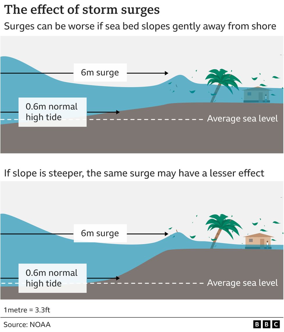
The area is among the most vulnerable places in the US for severe flooding – and if Ian continues on its expected path, this would be the region’s first direct hit by a major hurricane since 1921.
“It’s been around 100 years since Tampa had a direct hit. They’ve just been lucky for a long time,” said Erik Salna, associate director of the International Hurricane Research Center.
Low elevation, rising sea levels, and a large population increase the risk of a catastrophic tidal surge. The Tampa area has all three, according to Mr Salna.
If hit directly, the region could be “unrecognisable” in the next couple of days, he said. “The potential is there.”
Hurricane Ian was about 75 miles (125km) off the coast at 05:00 local time (09:00 GMT) when the NHC announced it had become a category four storm, as reported by air force hurricane hunters.
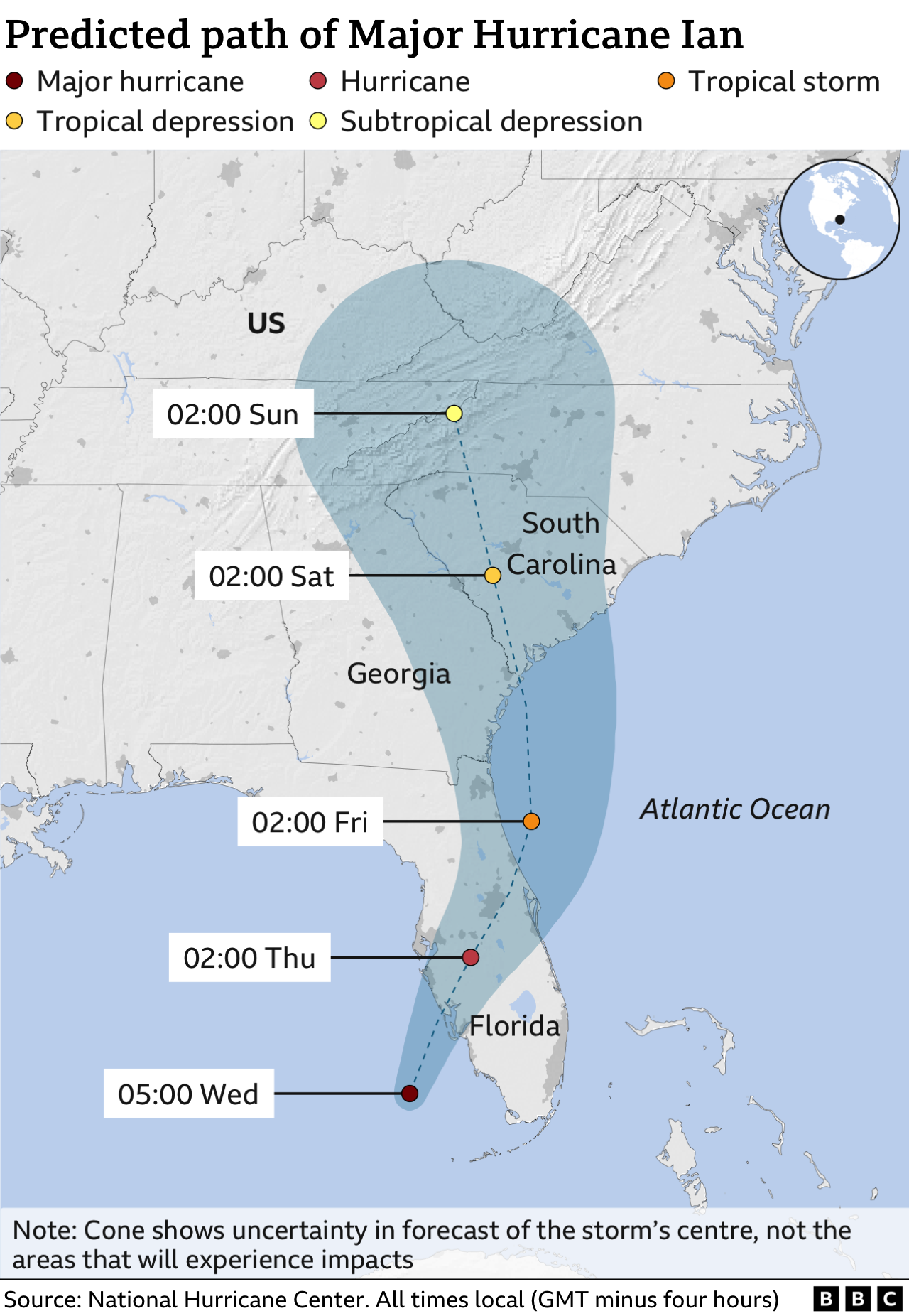

People in the highest risk areas such as Charlotte county, where the hurricane is expected to make landfall, have been urged to “hunker down and prepare for the storm”.
Governor DeSantis said: “It’s no longer possible to safely evacuate”, adding that people should keep off the roads and make their way to shelters.
The area at highest risk spreads from Naples to the Sarasota region, said the NHC.
Tornados have already been seen in southern Florida, the National Weather Service said, as Ian approached the coast. Conditions were “rapidly deteriorating” along the south west coast of Florida at 06:00 local time (11:00 GMT), the NHC reported.
In a tweet, the center said a buoy located north-north west of the storm’s eye had recently measured a sustained wind of 106 km/h (66 mph) and a weather flow station near Sanibel Island recorded a sustained wind of 63 km/h (39 mph).
Ian is likely to lose speed as it nears Florida, effectively prolonging the storm’s effects and threatening up to 20in (1.6ft) of rain in some areas.
Governor DeSantis said there was a “major” recovery effort in place for after the storm has passed including emergency services and linemen.
He urged residents to be “cautious” and avoid hazards such as down power lines, standing water and damaged trees.
And if it does hit Tampa, it will strike one of the state’s most densely populated areas.
Over the last 50 years, development has surged along the Tampa region’s nearly 700 miles (1,1200km) of shoreline, with people and buildings scattered along the mostly low-lying beach.
This video can not be played
To play this video you need to enable JavaScript in your browser.
“We’ve moved toward the coast, we’ve moved toward the water. This is, in its own way, a human nature trainwreck,” said Richard Olson, director of the extreme events institute at Florida International University (FIU).
Mr Olson said his “constant worry” as Hurricane Ian neared the coast was “under-evacuation”. More than 2.5 million Florida residents in a number of coastal towns and cities have begun to evacuate, with police going door-to-door in some areas and pleading with people to leave.
Tampa Bay Mayor Jane Castor said on Tuesday that the city would also be implementing a curfew for remaining residents.
“This is not a drill,” Mayor Castor told residents. “I don’t know that it can get much worse, but I’m sure that there’s a scenario that it can.”
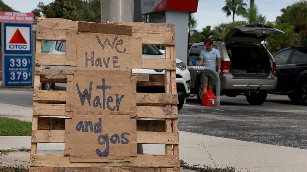
Image source, Getty Images
Governor DeSantis issued his own warning on Tuesday, telling those in an evacuation zone, “your time is coming to an end”, adding if people had still not made a decision then “now’s the time to act”.
The National Hurricane Center said there was a 100% chance of damaging winds and water along Florida’s west coast, issuing a hurricane warning 175 miles wide, from Bonita Beach in the south to Anclote River, north of Tampa.
Residents have been buying water bottles in bulk, boarding up windows and moving garden furniture inside. Schools and universities have also cancelled classes for the week.
Theme parks such as Disney World, Sea World and Busch Gardens in Tampa are closing as the storm bears down, while Nasa has postponed the planned launch of a moon rocket at Kennedy Space Center.
The Artemis I Moon rocket – which has already had its launch postponed twice – has been removed from the launchpad to the vehicle assembly building to protect it from the approaching storm.
As flights landed in Tampa on Tuesday, mobile phone alerts blared notifying residents of mandatory evacuation orders across the region.
In the airport, one man said he had not faced the prospect of a hurricane like this in his 43 years of living in the area. “It’s the calm before the storm,” he said.
The hope for Tampa residents is that the storm moves slightly south, making landfall in the less-populous Fort Myers region.